This post may contain affiliate links. We may earn money or products from the highlighted keywords or companies or banners mentioned in this post.
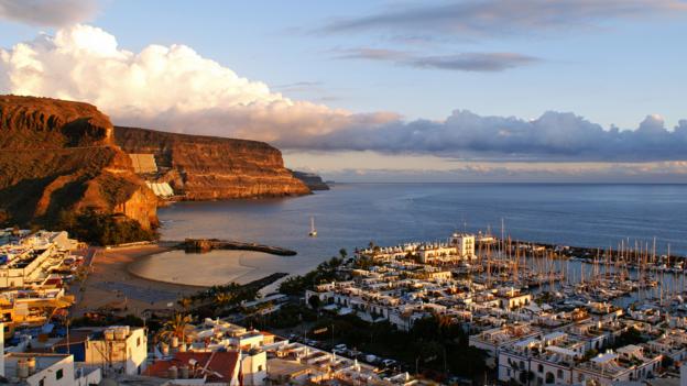
Everyone’s heard of Spain’s Camino de Santiago, the 100km-plus Way of St James route that leads pilgrims to Galicia’s cathedral of Santiago de Compostela, where the saint’s remains are believed to be buried. But it will probably come as some surprise to learn there’s another Camino 1,750km to the south, on the mid-Atlantic island of Gran Canaria.
This pilgrimage is so unknown that even people on the island couldn’t seem to give me any information. The details provided by the island’s official tourist board proved sketchy; a pair of French walkers hadn’t heard of the trail and a toothless local suggested I walk along the main road instead. Undeterred, I did my best to keep on track, determined to finish what I’d started.
The world-famous Camino de Santiago had been on my bucket list for many years. I’d heard that its length requires an endurance that separates the hikers from the schleppers, and I was eager to prove my strength after a lifetime of trekking. But then I discovered that only 1% of it takes place on a dirt track; the rest is made up of roads and motorways. I also didn’t want to become just another roadie, one of the around 300,000 hikers who complete the epic trek every year. I was looking for a less-crowded, more spiritual pilgrimage – which was how I found out about this second Camino de Santiago, where 99% of the route is on a dirt track and only a handful of people walk it each year.
Gran Canaria’s Camino de Santiago historically ran between the island’s two major churches dedicated to St James: one in the south-central village of Tunte and the other in the town of Gáldar in the northwest. In 2011, the trail was extended southwards to create a coast-to-coast walk through the lush interior of Gran Canaria.
The island was colonised by the Spanish in the 15th Century as the Catholic monarchs Ferdinand of Aragon and Isabella of Castile sought to expand the newly unified country. The conquerors built a church dedicated to St James (their country’s patron saint) in Gáldar – the first Jacobean place of worship constructed away from the Spanish mainland.
Legend has it that Galician sailors ran aground off the coast of Arguineguín in the island’s southwest in the 16th Century. With them, they carried an image of St James on their shoulders as a way of giving thanks for arriving safe and sound on land. They placed this polychrome sculpture in a hermitage they constructed in the Valle de La Plata, before it was moved to the village church of Tunte in 1850. A pilgrimage from one church to the other soon developed, following the seasonal goat herds’ route from north to south and back again. This pilgrimage was originally walked by islanders who were looking for a miracle, or by those who had pledged to do so after their prayers were answered.
Today’s extended Camino de Santiago’s route (a 76.9km, three-day, three-stage hike) starts at the Maspalomas Tourist Information Office, which confusingly is not in the holiday spot of Maspalomas but in the neighbouring resort of Playa del Inglés. There, on a gaudy parade of piercing studios and tattoo parlours, I spotted the first Camino-related sign. (Keep an eye out for Ruta Jacobea signs as well, as the Camino de Santiago’s also known as the Jacobean Route.)
More by chance than by design, given a general scarcity of signage, I ended up on the second route option of the hike's first stage, heading through the Degollada de Garito, a sheer incline between ravines. I passed the eerie Arteara Necropolis, the burial ground of the Amazigh-descending canarii (Gran Canaria’s aboriginal people who occupied the island prior to the 15th-century Spanish conquest). My progress was largely a solitary one, save for a Jeep safari that created a whirlwind of dust. Dwarfed by the volcanic slopes that descended to the left and right of me, I felt humbled by the sheer force of nature.
Gran Canaria is celebrated for its light, but the sun goes down quickly. So, at 7 pm, I set up camp in an orchard close to the village of Fataga. The wind spookily whistled through the surrounding fruit trees, but I was comforted by the fact that I could see the odd car travelling along the nearby main road.
The next day, suitably refreshed, I was able to make up lost ground, reaching Tunte, where Gran Canaria’s original Camino de Santiago began, by mid-morning. Here, I paid my respects by stepping through the door of the church, which was constructed towards the end of the 17th Century over the former hermitage of San Bartolomé. Fittingly, an effigy of the saint, a missionary who brought Christianity to Armenia, still occupies the central part of the altarpiece. But I was more moved by the original statue of St James. Despite my not being particularly religious, I was awed by its presence.
The next section of the route was the 18.8km ascent to the heart of the island. My wife had packed my rucksack for me, and even trying it on in our living room, I’d stumbled under the weight. The burden became heavier as the path became steeper, and it was frustrating to see the odd cyclist whizz past. But my shoulders lifted with my spirits as I came to a clearing at the edge of a pine forest.
Ahead, I could see the distinctive shape of the rock formation Roque Bentayga; the mountain Teide loomed above it on the neighbouring island of Tenerife. To the left, I could make out El Fraile, a rock so called because its shape is reminiscent of a monk, and La Rana, which looks like a frog. Tired by a day’s hiking, the heart-stopping vista felt like a godsend. It was almost as if the monk was sharing a miracle with me.
The mountain air might have been sweet, but it was colder than the lower-altitude valley of Fataga. Given the island’s variety of climates and landscapes, I was beginning to understand why it’s known as the Miniature Continent. And so I spent a chilly night sleeping rough in the hamlet of Cruz de Tejeda, named after its totem-pole-esque stone cross that marks the island’s exact centre.
The third stage from Cruz to Tejeda to Gáldar is the easiest, descending 1,548m through forest and farmland. But the hard part was the lack of signs to Gáldar. And so I found myself having to retrace my steps from Artenara, the island’s highest village where many locals still live in cave houses, to the Pinos de Gáldar, a viewpoint lauded for its waterfall of clouds. The wind makes the vapours look like they’re cascading from the pine trees down to the pastoral landscape below. Save for the odd car that stopped to admire the view, I peered down alone from this mirador (viewpoint) before returning to my monk-like solitude on the downward path.
Approaching Gáldar, the landscape changed from pines to agricultural land. I passed banana plantations before arriving in front of my destination, the Iglesia de Santiago de los Caballeros, situated in one of Gran Canaria’s prettiest squares.
Entering into the peace and quiet of the church, I spotted the font in which the Spanish baptized the early Canarian converts to Christianity, along with another figurine of Saint James astride his horse. My walk finally over, I sat down to rest and reflect on my pilgrimage.
If I’d walked the original Camino de Santiago in Spain, I’d have reached my goal. There are only remains of the one body, after all. But my feet were already beginning to itch, and I wanted to be exploring more of the island’s great outdoors. My new bucket-list entry: to walk Gran Canaria’s Camino again – this time from north to south.
If you liked this story, sign up for the weekly bbc.com features newsletter, called “If You Only Read 6 Things This Week”. A handpicked selection of stories from BBC Future, Earth, Culture, Capital, Travel and Autos, delivered to your inbox every Friday.

